For adventurous souls, few road trips rival the raw, remote, and rugged beauty of the Dempster Highway. Stretching 576 mi / 972 km (one way!) from Dawson City, Yukon to Tuktoyaktuk, Northwest Territories, this iconic route is the only road in all of North American, where you can drive right up to the Arctic Ocean (without flying or hiring a shuttle).
Unlike other epic North American drives, the Dempster is incredibly remote and few will brave the journey. It’s dangerous, long, and just getting to the start requires an incredibly long journey in itself. The reward though? Completely worth it in our opinion. It’s not just a road—it’s a journey back in time, into pristine wilderness, and deep into the cultures of the North. If you’re dreaming of a true frontier experience, this is the road trip you must do at least once in your lifetime.
This blog post provides information from when we drove the Dempster in early August 2025. We hope this information is helpful if you’re planning your own trip. If you’d like to see more, you can check out our YouTube video here:
A Quick Overview: The Route
- Starting Point: Dawson City, Yukon
- Ending Point: Tuktoyaktuk, Northwest Territories
- Total Distance: 576 miles / 972 kilometers (one-way)
- Estimated Driving Time: 18 – 20 hours without stops (but plan at least 4–7 days round trip to explore properly)

Key Points of Interest & Mileage
- Dawson City (Mile 0) This historic gold rush town is where your journey begins. Stock up on supplies, fill your tank, and explore the charming streets lined with heritage buildings. Don’t miss the Sourtoe Cocktail at the Sourdough Downtown Hotel (if you dare)! There is also some great information on the Dempster at the Vistor’s Center here.
- Tombstone Territorial Park (Mile 52–Mile 91) Often called the “Patagonia of the North,” this park is famed for jagged peaks, colorful tundra, and abundant wildlife. We were planning on hiking to Grizzly Lake on our return, but unfortunately weather moved in and we didn’t want to be out in the elements for multiple hours. If you have time though, we have heard this is an excellent hike.
- Eagle Plains (Mile 254) This is the halfway point and home to one of the only service stations, a small hotel, and a restaurant. Definitely make sure to refuel here, as trying to get to the next service station in Fort McPherson could be pushing your luck. There is no town here—just a lonely outpost with critical amenities.
- Arctic Circle Crossing (Mile 252) A major milestone! Pull over at the Arctic Circle sign for a photo and take in the vast, treeless tundra stretching endlessly to the horizon.
- Fort McPherson (Mile 367) A Gwich’in community on the Peel River, Fort McPherson is a cultural and historical highlight. Being the long weekend when we were here, there was not a lot open, but we were told that a visit to Fish Camp is a must! Stop by and learn how they traditionally dry fish and speak with the locals.
- Inuvik (Mile 481) The largest town on the route and the only town where you will find an actual grocery store. We don’t recommend planning to do any major shopping here though, as prices can be very high! It’s best to stock up in Dawson or another town before you hit the Dempster. For restaurants, we recommend checking out Alestine’s. She cooks everything in a converted school bus and this place packs serious charm and delicious food.
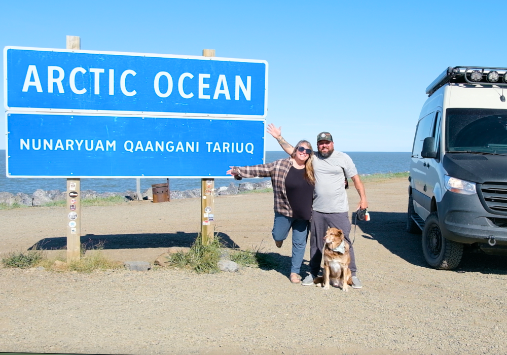
- Tuktoyaktuk (Mile 576) Welcome to the Arctic Ocean! This Inuvialuit Hamlet is the northernmost point in Canada you can drive to. Take a plunge in the Arctic Ocean, tour traditional sod houses, and learn about local traditions from community guides. Keep in mind, that this town has very limited services and if you are here on a long weekend like we were, most business will be closed.


Camping & Accommodations
Camping
When we drove the Dempster in August 2025, there were abundant wild camping options along the route. We did a mix of both wild camping and staying in campgrounds. Following are our campsites by each day.
- Night 1 (278 miles from Dawson City / 66.57891, -136.30022): Wild camping spot just beyond the Arctic Circle sign. This spot was up on a hill and provided stunning views into the valley below. Being on a hilltop, it was also more windy, but that was a welcome treat to help keep the mosquitoes and other bugs away.
- Night 2 (204 miles from the previous day / 68.35973, -133.73735): Happy Valley Territorial Campground in Inuvik. This is a serviced site with facilities, including showers and laundry. When we stayed, it was $35 CAD/night. This campground is located right in town and easily walkable to restaurants and shopping. Make sure to stop by Alestine’s for some fish tacos!
- Night 3 (95 miles from Inuvik / 69.45556, -133.03750): Tuktoyaktuk Camping area at the end of the road. This is less like a camping area and more like a parking lot with a couple of outhouses, but it looks like they are working on making improvements. When we were here, it was a long weekend, so there was no one to pay for the camping, but if you are here during regular days/hours, you will need to pay at the Visitor’s Center. We believe it is $20 CAD/night, but cannot confirm the exact amount.
- Night 4 (99 miles from Tuktoyaktuk / 68.33328, -133.65531): Jak Territorial Campground outside of Inuvik. This is another camping option in Inuvik and to be honest, we liked this campground a lot more than Happy Valley Territorial Campground. It is much quieter and the facilities are nicer. On the flip side, it is definitely not walking distance to town. It is $35 CAD/night.
- Night 5 (330 miles from Inuvik / 65.37520, -138.29203): Wild camping spot in an old gravel pit. This may not have been the prettiest of campsites, but it was big, level, and off the main road. After a long day of driving, we were just glad to have an easy place to call home for the night. There was one other van that stayed there, and would have been room for a lot more.


Other Camping Options:
- Tombstone Mountain Campground (Mile 70): Stunning views and well-maintained sites. Often fills up in summer.
- Engineer Creek Campground (Mile 145): Nestled by the Ogilvie River.
- Rock River Campground (Mile 302): Before entering the Northwest Territories.
Note: While wild camping is allowed in many areas along the Dempster, please respect the land and local regulations.
Hotels & Lodges
- Eagle Plains Hotel: They also have a restaurant here that we’ve been told is pretty good.
- Hotels in Inuvik: Capital Suites, Mackenzie Hotel
- Tuktoyaktuk Guesthouses: Some locals rent rooms or offer tours. Booking in advance is essential.
Weather Conditions & When to Go
Technically the Dempster Highway is open year-round, but we recommend driving it between mid-June and mid-September. Anytime outside of that and you could be caught in a dangerous storm and face horrible road conditions. Summer offers 24-hour daylight (midnight sun), wildflowers, and wildlife.
- June–July: Best weather, long days, and we have heard there are fewer bugs early in the season. If you can, time your arrival in Tuktoyaktuk with the Summer Solstice!
- August: Fall colors started to appear overnight when we were here in early August. Bugs were fierce though. We were warned about them and thought, ‘it can’t be that bad,’ but it really was that bad.
- September: Risk of early snow; carry chains and be prepared for rapidly changing conditions.
Outside of summer, the highway is icy and dangerous, and you could find yourself stranded for days.

What You Absolutely Need to Bring
Driving the Dempster is no ordinary road trip. It’s remote and self-reliance is critical. Here’s a list of must-haves:
Vehicle Essentials
- A reliable vehicle (AWD or 4×4 preferred)
- Two full-size spare tires (we only had one, but did end up getting a flat)
- Tire patch kit (we love this one from Black Rhino)
- Air compressor (like this one)
- Tire inflators (we like this quad inflator from Morrflate)
- Extra fuel (jerry cans)
- Recovery rope (like this Bubba Rope)
- Jack and tools
- Extra windshield washer fluid
- Extra oil, coolant, and fluids
Navigation & Communication
- Satellite phone or Garmin InReach / SPOT device at a minimum
- Physical maps (cell coverage is minimal to nonexistent)
- Detailed road logs (available at the Visitor’s Center in Dawson City)

Emergency & Safety Gear
- First aid kit
- Emergency blankets
- Fire extinguisher
- Food and water for 2–3 days minimum
- Bear spray
- Warm clothing layers (even in summer)
Wildlife & Road Hazards
This road is know for grizzly bears, caribou, moose, foxes, and eagles. While we didn’t see much, we did see two foxes. Regardless, it is important to remember to never approach or feed wildlife, and keep food stored properly.
The road surface is gravel, often sharp and rough. Drive slowly and cautiously—many travelers suffer multiple flat tires.
Watch for:
- Soft shoulders
- Pot holes, they can and will sneak up on you
- Muddy and slick sections of road
- Flying gravel from passing vehicles
- Heavy equipment/road construction
- Dust clouds that reduce visibility
- Sudden weather changes
- Ferries (There are two ferries you will have to use. Check hours and seasonal schedules.)


Towns & Services Overview
| Town/Stop | Fuel | Food | Lodging | Notes |
|---|---|---|---|---|
| Dawson City | ✔️ | ✔️ | ✔️ | Full services |
| Tombstone Park | ❌ | ❌ | ❌ | Camping only |
| Eagle Plains | ✔️ | ✔️ | ✔️ | Critical refuel point |
| Fort McPherson | ✔️ | ✔️ | Limited | Gwich’in community |
| Inuvik | ✔️ | ✔️ | ✔️ | Full services |
| Tuk | Limited | Limited | Limited | End of the road |
Why You Should Do This Trip at Least Once in Your Life
The Dempster Highway isn’t just a scenic drive—it’s a pilgrimage to one of the last true wilderness frontiers.
You’ll experience:
- Solitude like nowhere else in North America.
- Cultural richness through Indigenous communities welcoming travelers with stories and traditions.
- Geological wonders: Mountains, pingos, and arctic tundra.
- Northern wildlife if you’re lucky.
- The bragging rights of standing at the edge or actually in the Arctic Ocean, at the end of the world’s longest all-season road to the sea.
In a time when the world is increasingly connected, the Dempster offers a rare kind of freedom—where nature is untamed, and every mile is a step further from ordinary.
Final Tips
- Check road conditions before departure: Yukon 511 & NWT Highway Conditions
- Travel with others if possible
- Allow extra days in case of delays
- Be respectful to locals and land—leave no trace
Final Thoughts
The Dempster Highway is not for the faint of heart—but was one of the most rewarding trips we have done. Although we don’t know if we’d do it again (it was long!), we are so happy that we did. It truly is a once-in-a-lifetime type of adventure. There is nothing like seeing the end of the continent and jumping in that Arctic Ocean. Do it, you won’t regret it!


AFFILIATE DISCLAIMER: Some of the links above are affiliate links. If you choose to use them, we may earn a small commission at no extra cost to you. We only recommend products we use ourselves and love. This helps keep us on the road and making content. We appreciate your support!
Leave a Reply